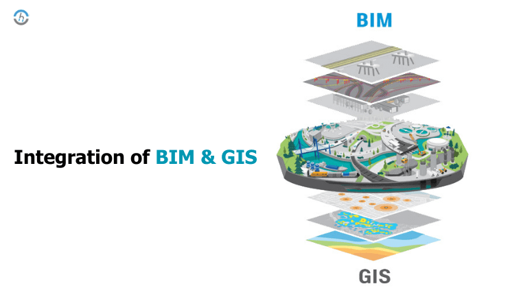
BIM (Building Information Modeling) and GIS (Geographic Information System) are stand-alone technologies performing individual functions. GIS maps data using spatial functionalities and geographical databases, while BIM uses object information models for asset documentation.
We should recognize the synergy of these technologies, which will often be used in sophisticated projects. BIM technologies are widely used in architectural and civil engineering projects, while GIS systems are primarily utilized in environmental tasks.
This blog will examine the advantages, disparities, and implementation of the GIS and BIM technologies.
What is (building information modeling) BIM?
BIM stands for building information modeling. It is a digital model of a facility that characterizes physical and functional features. Such fields continue beyond drafting and 3D modeling yet also encompass the geometry of space, spatial relationships, geographical information, and how much construction components are needed.
In contrast, BIM makes it possible to move an accurate information model from the design team through all levels of detail, subcontractors and the owner, who can add their data layers. This integrated approach is a proven coordination model that minimizes errors and maximizes project management efficiency.
What is GIS ( Geographic Information System)?
GIS, which stands for “Geographic Information System”, is an application that involves capturing, storing, analyzing and mapping geographical data. The main strength of geographic information systems (GIS) is its ability to attach information to particular areas, giving more insights to city planners, environment management agencies and resource development.
The main distinction between GIS and BIM is that the first is solely used for building construction, whereas the latter provides a more global background for space examination over large areas.
The technology relies on spatial data from different sources to assist in decision-making and gives trendy information that can not be observed with a traditional method. GIS technology increases the grasping opportunities in geographical spaces, making it possible for specialists in various areas like resource management and decision-making.
For example, Building Information Modelling (BIM) and Geographic Information Systems (GIS)
GIS (Geographic Information System) and BIM (Building Information Modeling) communicate real-time information about the existing environment of an asset to provide the necessary data. Application of this information allows designers and engineers to investigate and assess design and construction issues in-depth. Furthermore, utilizing only models allows us to do a more advanced and broad asset optimization, especially for operational and maintenance issues.
Integrating BIM and GIS into a solid model combines geographic and engineering data. The synergy achieved assists in a better understanding of the follow-up process, which makes daily operations more efficient and leads to positive project outcomes.
Application of BIM GIS Integration
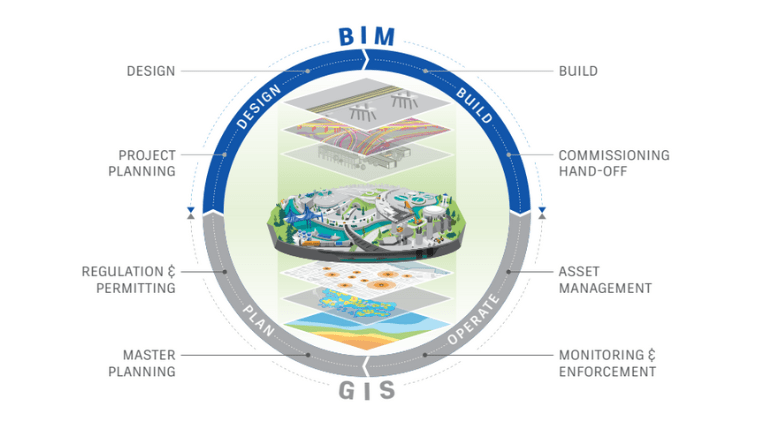
Connecting BIM and GIS also opens up possibilities in planning, design, and management for different sectors. It assists in accurate infrastructure planning for innovative city development, considering geographical features for maximum resource utilization.
BIM-GIS synergy can be used to design and manage highways, bridges, and tunnels, promoting knowledge and improving the environment. In the area of environmental protection, it can be applied in site disturbance assessment, flood risk analysis, and conservation planning for sustainable development. This bridges between the two systems, leading to faster workflow and also better decisions.
Visualization
The BIM-GIS platform allows the components to be seen in 3D with their geometric and semantic information. This visualization aids in project planning and execution; for instance, it can show the geographic terrain and facilities around and above the ground infrastructures in case they are in a GIS environment.
Facility Management
Daily and routine operations and keeping the utility running are indispensable. By integrating the BIM-GIS model, the team can access comprehensive utility information to efficiently locate, identify, and address utilities. Open utility data improves the whole system’s efficiency, shortens the duration of problems arising, and reduces expenses incurred.
Clash Detection
Renovation and repair activities are common during the operational stages. Traditionally, utility information is often unavailable or limited to 2D CAD drawings. Extracting precise utility details from 2D drawings is challenging and can lead to potential clashes between utilities.
Within this BIM-GIS integrated platform, various tools such as Civil 3D, Navisworks, and GIS tools like ArcGIS offer capabilities for clash detection in the 3D utility model. The 3D model enhances the provision of information crucial for subsequent actions.
Underground Utility Management System using BIM GIS Technology
Qualitative Metrics vs. Traditional Underground Utility in a BIM-GIS Based Integrated Framework:
| Qualitative Metrix | Traditional Underground Utility | Integrated Framework |
| 2D Visualization | Yes | Yes |
| 3D Visualization | No (Utility) | Yes (Traditional) |
| Quantity take-off | Manual (Utility) | Automated (Traditional) |
| Material Information | Besic (Utility) | Detailed (Traditional) |
| Data Sharing | Manual (Utility) | Automated (Traditional) |
| Excavator Operator Visualization | Yes | No |
| Utility Clash Analysis | Manual (hard) | Automated (easy) |
| Design Change | Manual | Automated |
| Facility Management | No | Yes |
Advantages of Integrating BIM with GIS
The merging of BIM and GIS technologies has a new impact on construction and urban planning, offering efficiency, accuracy, and sustainability. This integration of the planning and the development of solutions smooth the design and construction stages and results in more sustainable and resilient infrastructure development.
Through the integration of the rich data model sets of BIM with the geospatial and environmental information contexts of GIS, project teams can obtain a higher level of awareness of the situation. Analytical capabilities augment this awareness. This fusion provides a gateway that eventually enables the creation of breakthroughs to tackle such complex issues as climate change impact, urban spread, and resource scarcity, among others.
Furthermore, BIM-GIS integration facilitates enhanced stakeholder communication and collaboration throughout a project’s lifecycle. By providing a common, accessible platform for data sharing and visualization, stakeholders can make informed decisions, adapt to changes seamlessly, and identify opportunities for efficiency gains.
This collaborative environment fosters a culture of continuous improvement and innovation, driving the industry toward more innovative, more sustainable practices and outcomes.
Conclusions
Finally, using BIM and GIS in construction, urban planning, and environmental protection is a real game changer. This enlightened mix helps project teams to arrive at sound decisions, increase productivity and achieve sustainability.
The environment and remediation industries will largely benefit from adopting 3D BIM procedures and GIS technology. The future of BIM-GIS fusion is capable of altering the present infrastructure development process.
Technological advancements will lead to more powerful analytics, improved system interoperability and applications beyond the present ones. Advances in data collection, processing, and display will be used to increase the efficiency of design, construction, and maintenance operations. Adopting this integration is a determinant factor for the project’s success, keeping the environment and community positive in the industrial sector.