Are you confused with a question Why Point cloud to BIM conversion?
My blog is going to give you a clear vision for the Point Cloud to BIM conversion process and the purpose of Scan to BIM.
Firstly what Point cloud is?
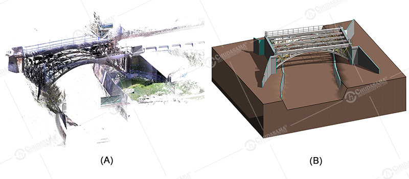
As the name itself indicates it’s a cloud of points, Measured and relate the formed points with the reference to one point in the space. As you can refer an image (A) below.
Probably this service is used for Existing Buildings Renovations, Building Surveying, House Extension, and Loft Conversion.
What is the process of Point cloud to BIM Conversion?
- Firstly the Building surveyor surveys the whole existing building with the help of a 3D laser Scanner (Faro). 3D laser scanner will give the information of dimensions generating a Point Cloud Model. That is it scans the whole building and generates a .pts file. You can refer image (A) below, which is a point cloud image. Then it is converted into .rcp (ReCAP) file, which is compatible with Revit Software. Then Modeling is created to accomplish the model into the Point Cloud File.
- Normally Software used is Revit, Tekla, Revit MEP, Bentley Systems and AutoCAD.
- Mostly it is used in MEP more because it shows less clash detection in comparison to Architecture or any other Software. It enhances the creation of an intelligent BIM model in Revit by providing accurate Point Cloud Data to the clients. It helps to measure points within the scan to find true dimensions quickly.
- The below-attached image represents 2 phases of Laser Scanning to BIM. It’s an image of a Bridge. It represents Steel Structure work. It was created in Revit Software and was quite interesting work to do.
 We here at Chudasama Outsourcing Pvt. Ltd. provide Laser Scanning to BIM services. And have excellent experience working with overseas clients on these projects. One of our recent projects is below.